Lêer:Regions of Europe Map.png
Grootte van hierdie voorskou: 800 × 531 piksels. Ander resolusies: 320 × 212 piksels | 640 × 425 piksels | 1 070 × 710 piksels.
Oorspronklike lêer (1 070 × 710 piksels, lêergrootte: 319 KG, MIME-tipe: image/png)
Opsomming
| Beskrywing |
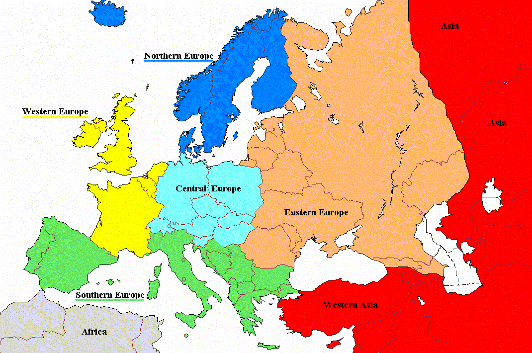
English: Regions of Europe with labels and corrected coloring |
| Datum | |
| Bron | File:Regions_of_Europe_Map.png |
| Outeur | Koyos |
| Ander weergawes |
|

Lisensiëring
| Ek, die outeursreghouer van hierdie werk, stel dit hiermee in die publieke domein vry. Dit geld wêreldwyd. In sommige lande is dit dalk nie wettiglik moontlik nie. Indien so: Ek verleen aan enigiemand die reg om hierdie werk te gebruik vir enige doel, sonder voorwaardes, tensy sulke voorwaardes deur die wet vereis word. |
Lêergeskiedenis
Klik op die datum/tyd om te sien hoe die lêer destyds gelyk het.
| Datum/Tyd | Duimnael | Dimensies | Gebruiker | Opmerking | |
|---|---|---|---|---|---|
| huidig | 10:06, 19 Augustus 2022 | | 1 070 × 710 (319 KG) | Рагин1987 | Cyprus shaded |
| 06:01, 28 November 2011 |  | 1 070 × 710 (171 KG) | DerFreischutz | Changed color according to the boundary. Everything above the border is Eastern Europe. | |
| 09:48, 3 Februarie 2009 |  | 1 070 × 710 (150 KG) | Koyos | reverting geographically inaccurate color coding | |
| 10:40, 18 Julie 2008 |  | 1 070 × 710 (57 KG) | Aegean Boy~commonswiki | {{Information |Description= |Source= |Date= |Author= |Permission= |other_versions= }} | |
| 09:29, 23 Augustus 2006 |  | 1 070 × 710 (150 KG) | Aongus | {{Information |Description=Regions of Europe |Permission= {{PD}} }} |
Lêergebruik
Die volgende bladsy gebruik dié lêer:
Globale lêergebruik
Die volgende ander wiki's gebruik hierdie lêer:
- Gebruik in cdo.wikipedia.org
- Gebruik in de.wiktionary.org
- Gebruik in es.wikipedia.org
- Gebruik in nl.wiktionary.org
- Gebruik in sh.wikipedia.org
- Gebruik in sl.wiktionary.org
- Gebruik in sq.wikipedia.org
- Gebruik in sr.wikipedia.org